I again am testing blog-posting procedure on the upgraded version of ptleader.com. If the intended illustration here does not post, I will be able to neither replace it nor delete the then-meaningless text. Bear with me as I learn the ropes, Old dogs such as I don’t take kindly to new tricks, and I’m already half-maddened by computer upgrades.
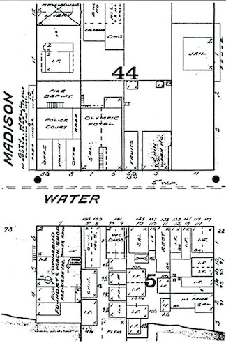
This is just another illustration from my archives at iCloud, which took it upon itself to kidnap all of my old desktop files when I upgraded to my current Apple computer, then got suckered into still another operating system upgrade more in tune with young technological hot-shots 65 or 70 years my junior. This illustration is from the elaborate 1891 map (produced professionally in San Francisco) and was kept at the fire house, It identified the contents of every structure in the city so that fire-fighters could immediately evaluate the situation of any fire. Fire engines were horse drawn, and crews of runners hauled the hose carts from the fire department iat city hall. Pity the poor horses being whipped to respond to Uptown fires!
This single map portion shows the current city hall, then still under final stages of construction at Water & Madison Sts. Directly behind it (labeled I. F.) is the Green Light, a 2-story structure that was was one the fancier bordellos of the day. “I. F.” indicated “ill fame,” and the entire area across Water Street from City Hall, contained mainly the cribs of assorted “soiled doves.” This structure later was conveniently destroyed by fire.
The wording is difficult to make out here in this reduced version of the quite-large original fire map, but “I. F.” can be found some 14 times and “ill fame” written out over another string of 4 small structures.
Dominating the west side of the partial block fronting the bay (now largely the city’s Pope Park) is the Port Townsend Foundry & Machine Shop. Next to it are an “I. F.” premises, plus two structures identified as Chinese, one a wash house. I wonder what the work atmosphere was like for those employed in the foundry. A saloon and a restaurant are mixed in with the various domiciles of self-employed professional women filling the rest of the block.
Fights among drunken sailors and others were common and there were periodic fatal shootings in this neighborhood. Prostitutes were hauled into justice court and fined every now and then.
Other dens of unbridled iniquity were scattered here and there on the fringes of the downtown business area, including Adams Street between Washington and Jefferson, the upper rooms of certain saloons, etc. Many modern-day residents have attempted to assume and apply this colorful history of prostitution to their newly purchased homes and business places, including some Uptown—but there is no historic basis or evidence to support such claims.
Next to city hall on the map is the Olympic Hotel and saloon. Beyond that is a fruit stand‚ and past that a Chinese wash house. Over on Monroe Street is seen the old jail that served the community prior to the jail cells in the basement of City Hall. My 2000 first volume of early local history, containing considerable detail related to this map, sadly is now “out of print” after 2,500 copies but can be scanned at the local historical society’s research center on the Chimacum cutoff highway.
I have in my possession the one and only copy of this entire old fire map, passed on down to me from former fire chief Otto Mitton via his son, long-time Leader printer Claude Mitton. It is a unique historical document. The original names of some of the city’s original streets alone are a revelation.


