A sixth nominee has been added to the list of names the Port Townsend School Board is considering for the new elementary school.
Grant Street Elementary is being replaced with a new school, slated …
This item is available in full to subscribers.
We have recently launched a new and improved website. To continue reading, you will need to either log into your subscriber account, or purchase a new subscription.
If you had an active account on our previous website, then you have an account here. Simply reset your password to regain access to your account.
If you did not have an account on our previous website, but are a current print subscriber, click here to set up your website account.
Otherwise, click here to view your options for subscribing.
* Having trouble? Call our circulation department at 360-385-2900, or email our support.
Please log in to continue |
|
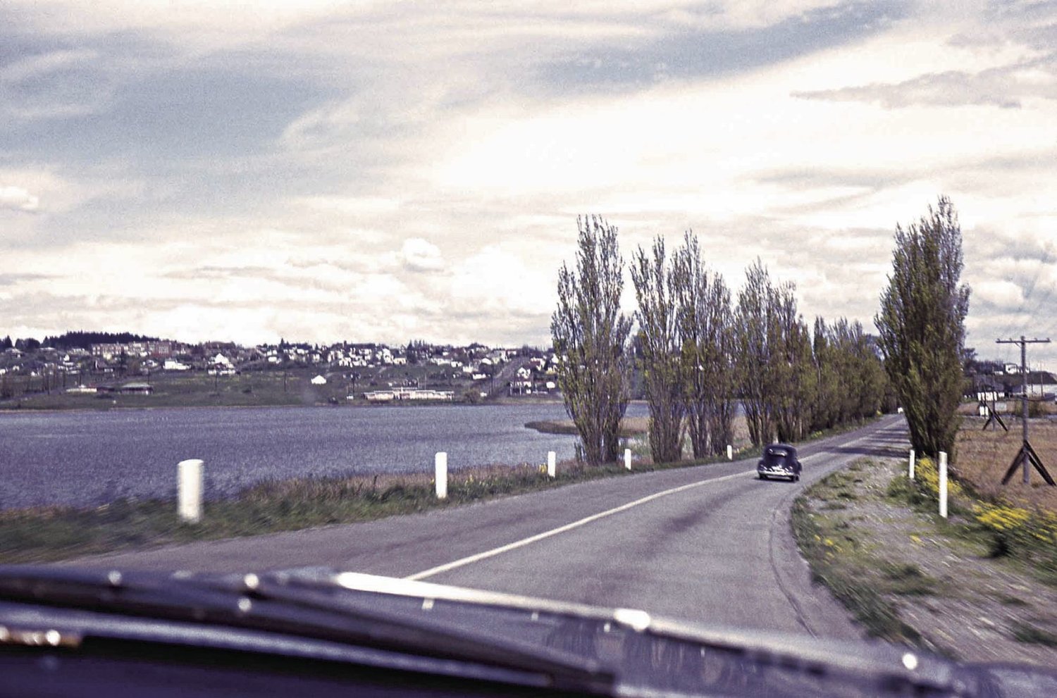
This is how Kah Tai Lagoon appeared in 1960 while descending the Sims Way “S” curve. The Port Townsend Boat Haven expansion in the early 1960s put 231,000 yards of dredged sand into the lagoon. The resulting change allowed the Port Townsend Safeway store to relocate in 1981. Kah Tai Nature Lagoon Park was created in 1985. Photo courtesy Puget Sound Coast Artillery Museum Collection
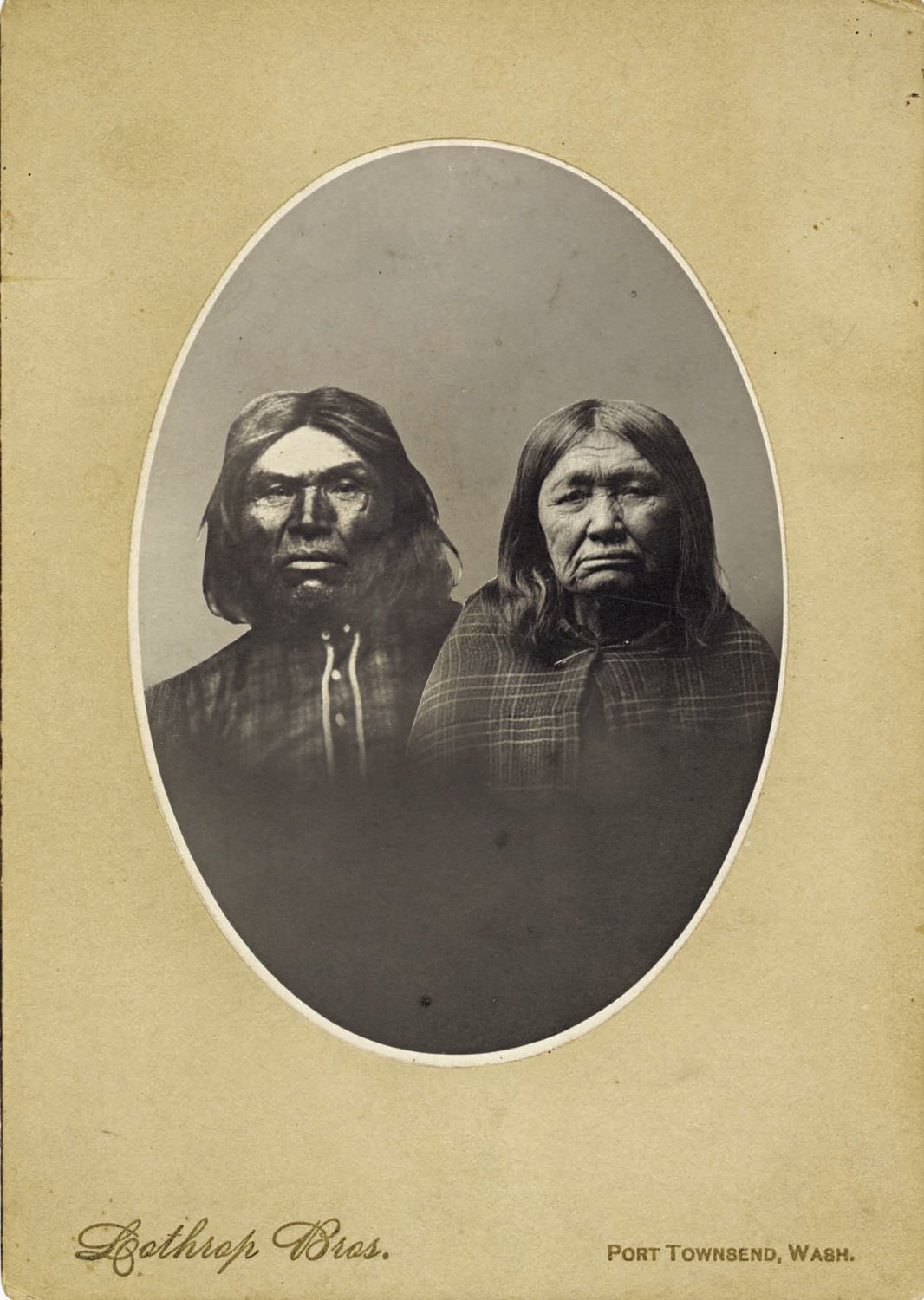
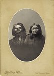
T’chits-a-ma-hun and his wife, Seeheimetza. The S’Klallam chief, who was friendly to Port Townsend’s white settlers, died in 1888. His descendants are members of the Jamestown S’Klallam Tribe. Photo courtesy Jefferson County Historical Society Collection
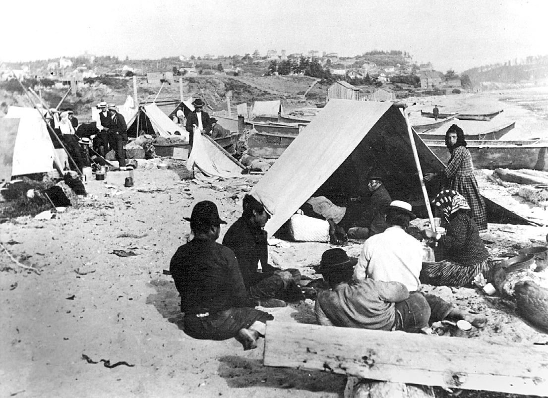
S’Klallam tribal members, pictured here at Point Hudson in the late 1800s, are among the Coast Salish tribes that used cedar canoes to travel great distances. The S’Klallams knew the area that later became Port Townsend as “Kah Tai.” Photo courtesy Jefferson County Historical Society Collection

A sixth nominee has been added to the list of names the Port Townsend School Board is considering for the new elementary school.
Grant Street Elementary is being replaced with a new school, slated to open in September 2018. The new school merits a new name, district officials decided. Elementary students and the general public were asked for suggestions, and the list of 131 nominees has been pared down to six: Chetzemoka, Discovery, Kah Tai, Salish Point, Salish Sea and Salish Trails.
Unlike the district’s most recent school-naming propositions, when students made the final choice of Blue Heron and Mountain View, the school board is slated to make this decision March 13.
Public input is sought in a meeting starting at 5 p.m., Monday, Feb. 27 in Room S-11 of the Gael Stuart Building, 1610 Blaine St., on the high school campus.
School board members on Jan. 23 discussed changing the elementary school’s mascot or logo, and it was decided to retain the “Eagles” moniker, noted Lisa Condran, Grant Street principal.
From the original 131 nominations, the committee advanced 17 names for consideration: Margaret Berry (former superintendent of schools), Castle Hill, Chetzemoka, James “Bonzo” DeLeo (former community leader), Discovery, Douglas Fir, Evergreen, Grant Street, Kah Tai, Marvin G. Shields (PTHS graduate and U.S. Navy Seabee Medal of Honor recipient from Vietnam War), New Discovery, Rhododendron View, Puget Sound, Salish Point, Salish Sea, Salish Trails and Trillium.
Applying a scoring matrix, the committee chose five finalists with the following scores: Salish Sea 26.1 points, Chetzemoka 23.7, Salish Trails 22.8, Kah Tai 22.4, and Salish Point 22.4.
The committee reviewed the information, including the many nominations with Salish in the name, and decided to add the name Salish Coast Elementary. The six names were then scored again, with the following ranking: Salish Sea 28, Salish Coast 27, Salish Trails 23, Chetzemoka 23, Kah Tai 23 and Salish Point 19.
Based on that list, Salish Point was removed from it, and the other five names forwarded as finalists.
The school administration added the name Discovery again, raising the final choices to six.
The selection criteria for names containing geographic features, with one to five points each with a maximum possible of 30, included regional geographic/natural characteristics or geographic-related industries; a name that would be unique and inspiring; being meaningful to elementary school students; providing a connection with our people, our place and our community values; a connection with the geographic/natural characteristics of the school site; and a name that sounds pleasant and is easy for students to pronounce.
Leader research from a variety of sources offers the following historical perspective on the school-name choices:
CHETZEMOKA
About 500 S’Klallams were living in a camp along this peninsula when white settlers began arriving in the early 1850s to settle what became Port Townsend. The natives called this place Kah Tai.
T’chits-a-ma-hun (or Cheech-Ma-Ham) was apparently born in 1808 at Kah Tai. He became S’Klallam chief not long after settlers arrived. The settlers found his name difficult to pronounce, so he was called Chetzemoka, and in keeping with the English tendency of the time, given a royal nickname: Duke of York.
In 1855, he was the chief who helped convince chiefs from 15 tribes to sign the Point No Point Treaty with territorial Gov. Isaac Stevens, assigning fishing and hunting rights recognized to this day.
Chetzemoka is credited with easing tension between natives and whites on several occasions in the 1850s and 1860s, including standing on a rock in the fall of 1857 on the present-day site of the Port Townsend Golf Course and signaling to his white friends about tribal deliberations taking place on whether or not to attack the local settlers.
He died in 1888 on Indian Island, across the bay from PT. The town honored its friend by having his body lie in state for two days in the Enoch Fowler Building (1874), which was used as the county courthouse at the time, so the pioneers could pay their respects. (Since 1916, the building has been The Leader newspaper office.)
The Seattle Weekly Intelligencer reported at the time that “no Indian in Washington Territory, and very likely none in the United States, ever received so flattering a funeral as did the Duke of York.”
Chetzemoka is buried in Laurel Grove Cemetery. The inscription on his monument reads “Chetzemoka (Duke of York) the White Mans Friend. We Honor His Name.”
In 1904 when Port Townsend’s first public park was created, the initial choice for a name was Kulshan, the native word for Mount Baker. It was eventually decided that the name of Chetzemoka had more local significance.
In 1994, the name Chetzemoka was one of three finalists when the Port Townsend School District opened a new middle school. Students chose Blue Heron as its name.
When Washington State Ferries solicited nominations to name new 64-car ferries designed specifically for the Port Townsend–Coupeville route, the Jefferson County Historical Society championed the name of Chetzemoka for the first boat. Launched in 2010, the Chetzemoka has served the Point Defiance–Tahlequah route since 2012. Chetzemoka was also the name of a ferry used in Puget Sound from 1938 to 1973.
DISCOVERY
British Royal Navy Capt. George Vancouver sailed into this area in 1792 aboard the 96-foot HMS Discovery. The bay west of what became Port Townsend was named Discovery Bay, although it turned out to be a dead end in Vancouver’s expedition, which continued into what became Puget Sound. The captain used the ship to cover 65,000 miles in four and a half years.
The Port Townsend School District in 2013 launched the five-year Maritime Discovery Schools initiative, a collaborative effort with the Northwest Maritime Center aimed at transforming K-12 public education in Port Townsend into an experiential, place-based education in a maritime framework.
The new elementary school’s front door would face Discovery Road. The existing school fronts Grant Street.
KAH TAI
The S’Klallams knew this peninsula as Kah Tai, which means “to carry” or “pass through”; it’s believed that canoes were portaged roughly from what today is the North Beach area to the lagoon that bears that name as a means of avoiding the strong currents at Point Wilson. It’s also believed the lack of abundant fresh water made this a site of a seasonal village.
Originally, the body of water known as Kah Tai was a broad salt marsh extending from the bay. It provided the S’Klallams with waterfowl as a food source. In 1891, settlers built a bridge across the lagoon from Lawrence Street to the developing residential area. The town’s refuse dump became the lagoon, although the dumping stopped for the most part by 1907, when the bridge ceased to become passable.
The community’s love-hate relationship with the lagoon continued. By 1930, a road was built (Sims Way) to better access the new paper mill. The elevated roadway blocked Kah Tai from the bay’s tidal action. Efforts were made to plant trees, remove the old bridge, plant wild rice and seed the lagoon with trout. The fish did not last, but the rice attracted a lot of ducks.
The Port of Port Townsend’s effort to expand the boat haven in the early 1960s allowed the U.S. Army Corps of Engineers, over the objections of some, to dispose of 231,000 yards of dredged sand into the lagoon. By 1976, the sandy area was covered with at least 70 varieties of grasses, trees and shrubs. Port district officials in the late 1960s and again in the 1970s proposed commercial development for its Kah Tai property.
In the late 1970s, Safeway’s plans to relocate its grocery from downtown to property south of the lagoon drew a legal protest that eventually went to the state Supreme Court. Although the Kah Tai Alliance lost and Safeway opened in 1981, the effort did lead city officials to proceed with plans for a public park. A federal grant to purchase 80 acres of private land around the lagoon was obtained, and it opened in 1985 as Kah Tai Lagoon Nature Park. The water still does not support fish, but waterfowl and other birds abound.
In 1981, the Port Townsend School Board approved a suggestion to rename the junior high as Kah Tai School, but apparently the change was short-lived.
The Kah Tai Valley, between the Strait of Juan de Fuca and Port Townsend Bay once was open prairie. A 1.4-acre section on the city-owned golf course remained basically untouched, and in 1986, the Olympic Chapter of the Washington Native Plant Society recognized it as a unique botanical site. The Kah Tai Preserve was created in 1987, home to some 90 species. It blooms spectacularly each spring.
The name Kah Tai was also associated for about 50 years with a nursing home along the lagoon, which opened in 1956, after the structure had been built a few years earlier as a hotel. The nursing home eventually became known as Kah Tai Care Center. Purchased in 1996 by Life Care Centers of America, the facility’s name was changed in 2009 to Life Care Center of Port Townsend.
SALISH
Salish is a term used by linguists to describe the peoples and languages of tribes in the Pacific Northwest. The Coast Salish are a group of ethnically and linguistically related indigenous peoples of the Pacific Northwest coast, living in British Columbia, Canada, and the U.S. states of Washington and Oregon.
The Jamestown S’Klallam Tribe, which is the “home” tribe of the Port Townsend area, offers this description: “For ten thousand years, a Nation of people lived and prospered on the lands now known as the Olympic Peninsula in the State of Washington. These strong people of the S’Klallam Tribes had a system of governance, engaged in commerce, managed natural and human resources, and exercised power over their homelands. The S’Klallams created a rich culture of art, song, spirituality, traditional knowledge and social structure. The S’Klallam culture promoted leadership, self-sufficiency, self-reliance and a code of conduct within their community that served as a basis for strength, pride and survival. This was a Nation, a government and a community, independent and interdependent.”
In 2009, the Washington State Board on Geographic Names approved a proposal to use Salish Sea as the collective name for the body of water that includes Puget Sound, the Strait of Juan de Fuca and Georgia Strait. The designation does not change or eliminate the names of any of the several bodies of water within the Salish Sea on either side of the international border. However, the proposal mandates that cartographers must use Salish Sea on all maps and in all atlases.
Washington State Ferries in 2011 launched the MV Salish, which serves the Port Townsend–Coupeville route.


